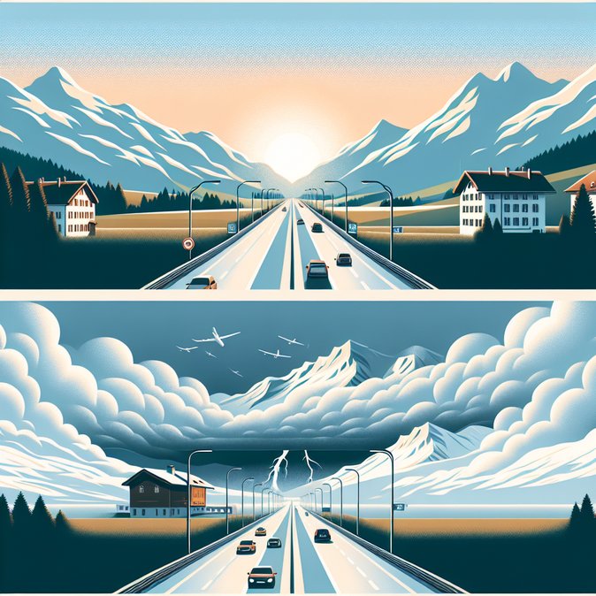
A Sunday-morning bulletin from Swiss news service imTicker paints a mixed mobility picture for December 7. After a damp start, forecasters warn that the snow-line will jump from 1,500 m to roughly 2,300 m by late afternoon, bringing heavy rain to lower valleys and up to 40 cm of fresh snow above 2,500 m. The good news: at 08:00 CET all national motorways—including the A2 Gotthard Tunnel and the A1 spine between Geneva, Bern and Zurich—were congestion-free, offering a rare ‘green-board’ snapshot for a December weekend.
Touring Club Switzerland (TCS) nevertheless cautioned drivers that storm-force west-to-north-west winds could hit mountain passes after dusk, especially on the Albula and Julier routes favoured by holiday traffic. Rail operator SBB said its engineering crews are on stand-by for potential tree-fall along the Central Plateau lines, while regional carrier Helvetic Airways pre-emptively swapped Embraer E195-E2 jets for the more wind-robust E190 on several domestic rotations.
If the evolving weather forces international travellers to adjust entry dates or transit plans, VisaHQ can streamline any last-minute visa or travel-authorization paperwork. Their user-friendly portal (https://www.visahq.com/switzerland/) provides up-to-date Swiss entry requirements, fast document processing and real-time status alerts—handy for logistics coordinators rerouting staff as well as tourists hoping to catch fresh Alpine snow.
![Swiss weather alert raises snow-line to 2,300 m—Alpine travel largely clear but storm winds forecast for evening]()
For mobility managers the day offers a brief window to move equipment and personnel before conditions deteriorate. Logistics firms transporting high-value pharma cargo through the Alps reported normal transit times in the morning but activated ‘plan-B’ routings via the Lötschberg base tunnel should the A2 experience wind closures. Employers with staff in remote ski resorts were advised to monitor cantonal avalanche bulletins, as the rapid rise in temperature can destabilise new snow layers.
Cantonal police in Uri and Graubünden urged motorists to carry chains and to avoid relying solely on sat-nav, noting that digital maps don’t always reflect temporary winter closures. Meanwhile, tourist boards seized the calm morning to push last-minute “storm-watching” packages—an increasingly popular niche for digital nomads who combine remote work with dramatic Alpine weather.
The federal MeteoSwiss service issues its next update at 16:00; companies with evening flights or late-shift commuters should watch for potential orange-level wind warnings that could trigger speed restrictions on exposed motorway viaducts and force airlines to impose stricter payload limits.
Touring Club Switzerland (TCS) nevertheless cautioned drivers that storm-force west-to-north-west winds could hit mountain passes after dusk, especially on the Albula and Julier routes favoured by holiday traffic. Rail operator SBB said its engineering crews are on stand-by for potential tree-fall along the Central Plateau lines, while regional carrier Helvetic Airways pre-emptively swapped Embraer E195-E2 jets for the more wind-robust E190 on several domestic rotations.
If the evolving weather forces international travellers to adjust entry dates or transit plans, VisaHQ can streamline any last-minute visa or travel-authorization paperwork. Their user-friendly portal (https://www.visahq.com/switzerland/) provides up-to-date Swiss entry requirements, fast document processing and real-time status alerts—handy for logistics coordinators rerouting staff as well as tourists hoping to catch fresh Alpine snow.

For mobility managers the day offers a brief window to move equipment and personnel before conditions deteriorate. Logistics firms transporting high-value pharma cargo through the Alps reported normal transit times in the morning but activated ‘plan-B’ routings via the Lötschberg base tunnel should the A2 experience wind closures. Employers with staff in remote ski resorts were advised to monitor cantonal avalanche bulletins, as the rapid rise in temperature can destabilise new snow layers.
Cantonal police in Uri and Graubünden urged motorists to carry chains and to avoid relying solely on sat-nav, noting that digital maps don’t always reflect temporary winter closures. Meanwhile, tourist boards seized the calm morning to push last-minute “storm-watching” packages—an increasingly popular niche for digital nomads who combine remote work with dramatic Alpine weather.
The federal MeteoSwiss service issues its next update at 16:00; companies with evening flights or late-shift commuters should watch for potential orange-level wind warnings that could trigger speed restrictions on exposed motorway viaducts and force airlines to impose stricter payload limits.